Prepare new data for the greece maps:
New
Data:
Roads:
Please don't send "saved log's", because they have a bad quality.
Better less data with good accuracy.
Also, don't send IMG's updeted with your data. Every day I get new
data, so my IMG version is always more up to date.
I can't use your IMG, and it's not possible to find your updates in the
IMG (in an easy way). So
please send only gps tracks.
To record data with the GPS, use a high accuracy in the GPS track log
menu for driving roads,
and the highest for walking (or use a 10 or 20 meter interval, this is
enough for one day).
I reduce the track point with a filter.
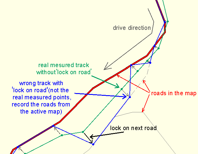
If you have routable maps in the GPS unit, switch off "Lock on road".
If "Lock on road" is on, the unit don't record the real track points.
The track snap to the next road. So the unit record only the existing road in the map.
But I need the real track points, because the maps are often inaccurate.
Sample:

Send only data with NEW roads (not in the map), or with better
accuracy than the existing in the map, and delete the other.
I need very much time to separate "old" and "new" data.
If you have existing, good roads and new roads in the same track, split
it in "new" and "old" parts.
Also split the tracks in the different road types (unpaved, paved,
highway, ...).
Save the different types (highway, main
road, small road, trail, ...)
in own files, for each type a new file.
And write the type in the track log comment or the file name.
Or save all tracks in the same file, with the road type in each track
comment/name.
The format can be all what Ozi/GTM/Mapsource/G7toWin/GPX can read.
To see which of your data are new and which are already in the maps
load the tracks e.g. in Mapsource over the GR maps.
new Points and POI's:
If you use Mapsource *.mps/*.gdb or Trackmaker *.gtm or Ozi *.wpt for
new point files (use
"Garmin Symbols" in the configuration),
select the correct symbol for the points.
Or write the type in the comment (e.g. restaurant or 0x2A00) before the
full name of the point.
Write the name of the point/POI in the comment field too, because the
waypoint name is often limited to 6 or 10 characters (lost information).
If there is no type
in the comment of a point (or a usable symbol) , I don't use
it.
Remember, not all waypoint symbols (from Mapsource/Ozi/GTM) have a
corresponding map (IMG) point symbol.
A list with all possible road, area and map point types you can find in
the
appendix of Mapdekode_Reference.pdf.
Corrections:
The best way to tell me errors, is to create a waypoint near the error
and write the changes in the comment
(new name, correct type of roads and points, new position of the point,
...).
You can send the data files to mapdekode@gmx.net.
Comments
to the roadtypes:
Type 01 (Major highway):
With two or more
lanes in each direction, central
reservation to separate the directions, with service strip and without crossroads
(only Highway exits with slow-down/acceleration lanes).
Type 02 (Principal highway):
With one or more
lanes in each direction, with or without central reservation and
crossroads.
Type 03 (Major raod):
With one lane in each
direction, without central reservation and crossroads.
Type 04 (Arterial road):
With one lane in each direction
Type 05 (Collector road):
With one lane in each direction, normal width
Type 06 (Residential street):
With one lane in each direction, narrow
Type 07 (Alley):
With one lane
Type 09 (Highway ramp):
With one or more lanes
Type 0C (Roundabout):
Type 0A (Unpaved road):
Unfortunately the only type without
asphalt!
Type 16 (Trail):
